Surrounding Villages

Ingleby

The LIDAR image shows the two deserted medieval villages of North and South Ingleby which now form the present settlement. The many earthworks which can be seen from the Sturton Road are the remains of the roads, fields and ponds which formed the villages.


In the centre of North Ingleby is a large manorial complex, which was bounded on three sides by a chain of fishponds forming a moat. Gables Manor Care Home, formerly Ingleby Hall built in 1879, now stands to one corner of this site. To the immediate south of the current Hall is the site of the manorial chapel, first mentioned in 1232. This may have been the original site of both the font and Daubney tomb, which were moved to St. Botolph’s Church when the chapel was abandoned. This site is a scheduled ancient monument.


An embankment surrounds a large field to the north of the Hall, described in 1569 as ‘the deer parke’ and 1650 as ‘The Park or the Deer Park’.


A further manor house at South Ingleby is recorded in 1304, with a dovecote and windmill. A mound, levelled in 1950, stood at the roadside between South Ingleby and Saxilby ; this may have been the site of the mill. A prominent bank, lying between the two villages, was possibly a rabbit warren.


The two villages were both held by the Daubney family during the 14th century. The lands passed first to Sir Thomas Burgh, and by 1539 to the Monsons of South Carlton. The cultivated fields were enclosed, and farming converted to sheep, which led to the decline in population.


In the extreme north-west corner of Ingleby is the site of a medieval monastic grange. The farm, known as Aldhagh, was owned and worked by the Augustinian Priory at Nocton. At the dissolution on the monasteries in 1534, ownership passed to Charles Brandon, Duke of Suffolk. In 1977, a possible boundary wall and spreads of limestone building debris over the lines of building foundations were discovered. Access from North Ingleby was presumably along a disused field way known as Old Wife Lane. Aldhow Grange now stands near the site.

We have produced a detailed guide to the Ingleby site which you can download here -

Broadholme

Broadholme Manor Farm stands on the site of the medieval nunnery of St. Mary, a priory of Premonstratensian canonesses founded before 1154 and dissolved in 1536. It was the first of only two nunneries of the order to be established in England in the Middle Ages. The Priory Seal is pictured left.

Closely associated with St. Botolph’s Church and Saxilby, the Priory was sponsored by the local Lords of the Manor and Royalty. A Charter signed by King Edward III, dated 27 February 1327 reads, ‘on account of the special affection which Queen Isabella, his most dear mother has towards them, grants to the Prioress and Nuns of Brodholme a yearly rent of 8 marks’. Lady Alicia Daubney was buried at the Priory in 1342.

Whilst vandalism and petty theft are often thought to be a current day problem, an incident recorded in 1383 proves otherwise. A complaint was made to the King that ‘William Wauterson, John in the Croft and John Henryson of Saxilby had broken into the Priory Close, felled trees and underwood, depastured the corn and grass, assaulted the servants, besieged the Prioress and her nuns, and threatened them with death’.

A valuation of all Church property was made in 1535, following the end of the jurisdiction of the Catholic Church. The valuation of Brodeholme Nunnery included rental income for Ingleby (10shillings) and Saxilby (£3/15s/6d), and out-goings for rent of 13s/4d paid to Lord Daubeney.

Now a scheduled monument, little evidence remains of the Priory. Some architectural fragments have been built into the existing farmhouse, and there are earthworks indicating fishponds to the rear of the property.

At the time of the map made in 1648, the priory had passed into private hands. The now renamed Brodeholme Hall and Church can be seen in the centre of the map, with the fishponds to the rear of the property. A post mill can be seen to the left.

Broxholme

Broxholme is situated between the villages of Saxilby and South Carlton. The population of this hamlet, never more than 150, has little changed over the centuries, yet has supported a church since at least the 11th century.

The survey of land for William the Conquerer taken in 1086 records that Broxholme has a church.

The hamlet formed part of the Manor of Ingleby until it was sold by Lord Monson in 1838.

Before chapels were built during the early 19th century, Methodists were allowed to use other buildings for the practice of religious worship. A certificate dated 25 October 1807 reads that ‘Thomas Chalnor, John Gray and George Boole certify that a certain dwelling house in the occupation of John Gray situate in the parish of Broxholm is intended to be used as a place of religious worship, for those . . . dissenting from the Church of England, commonly called Methodists’. The grandson of George Boole, also George, taught Latin and mathematics at a school in Doncaster from the age of 16, before returning to Lincoln where he opened an academy in Pottergate. It was here that he published a mathematical analysis of logic, to become known as ‘Booleian’ algebra, which forms the basis of modern computer logic. He was appointed Professor of Mathematics at Queen’s College, Dublin in 1849.

Hidden from view down a small lane is the closed parish church of All Saints and it's rectory, now in private ownership.

The church, a grade II listed building, was completely rebuilt in 1857 to a design by T C Hine of Nottingham. There are no existing images of the church which existed before this date. Many of the original 1857 fittings survive internally, including an unusual alter table, choir stalls and lectern. There are several areas of painted text on the interior walls. There is one bell in the tower.

The parish register, now held in the Lincolnshire Archives, dates from 1654.

The church plate, consisting of a silver paten, chalice and pitcher are now used regularly in St Botolph's Church, Saxilby.

The late 18th century grade II listed former rectory, now a house, underwent minor alterations in 1828 and 1840.
A religious census taken in 1851 records the population of Broxholme as 113. On the census day, 30 March, there was a congregation of 33, with 19 Sunday scholars. The rector was William Burnside.

The Lincolnshire Echo reported in 1969 that the Deanery Commission had recommended that the church be made redundant. The parish had been linked with Saxilby for over 10 years.

One local said 'the villagers don't want the church closed. An arrangement had been made with the previous incumbent (of Saxilby) that the villagers would let him know when they wanted services.'

By August 1989, the congregation had dwindled to an average of six, and had not been used for 10 months.

Estimates for repairs to the roof and guttering had been estimated at £20,000.

The Church Commisioners confirmed that the church would be made redundant, and it was closed in early 1990.

This quiet, secluded village boasts no fewer than five listed buildings, including the 17th century, mud and stud ‘Boontown Cottage’ (pictured). This old cottage stands so far from the road, that the postman would raise a flag on a pole by the side of the gate to let the residents know that a delivery had been made! Between the cottage and the road are the remaining earthworks and pond of a deserted medieval village, a scheduled ancient monument.

The Village Hall stood opposite the end of the track leading to Boontown Cottage. The First World I building hosted whist drives, dances and wedding receptions until the roof blew off during the 1980’s.

The population in 1991 was 56.

Drinsey Nook


A small hamlet of a few houses, straddling the border of Lincolnshire and Nottinghamshire. It sits on the banks of the Foss Navigation at the junction of the A57 Lincoln to Worksop road and the A156 Lincoln to Gainsborough road.


The name is derived from the Danish ‘Drenges Eye’, meaning ‘Dreng’s Island’. Like ‘Saxilby’ (Saxulf’s Farmstead), the name would have been given by Danish settlers following the Viking invasions of eastern England in the 8th and 9th centuries. 


Vikings came from the whole of Scandinavia. They did not have horns on their helmets (a Victorian invention!). The name means ‘sea pirate’.

Until the mid 18th century, each parish was responsible for the upkeep of all roads.


This situation changed when Turnpike Companies were formed. They became responsible for many 'main' roads, whose upkeep was paid from tolls. The modern route of the A57 follows the Lincoln to Worksop turnpike, which opened in 1756.


A daily stagecoach service between Lincoln and Sheffield was quickly introduced, which led to the expansion of coaching inns.


These inns, in addition to providing refreshment for travellers, also kept a change of horses. Such an inn was the predecessor of the existing building shown in the photograph.

For example, Charles Anderson wrote in his diary of his journey from Lea to Lincoln during the late 18th century - `We used in going to Lincoln to have horses from Lincoln to meet us at Drinsey Nook, otherwise we should never have got there. We generally had four horses, and the road used frequently to be under water'.
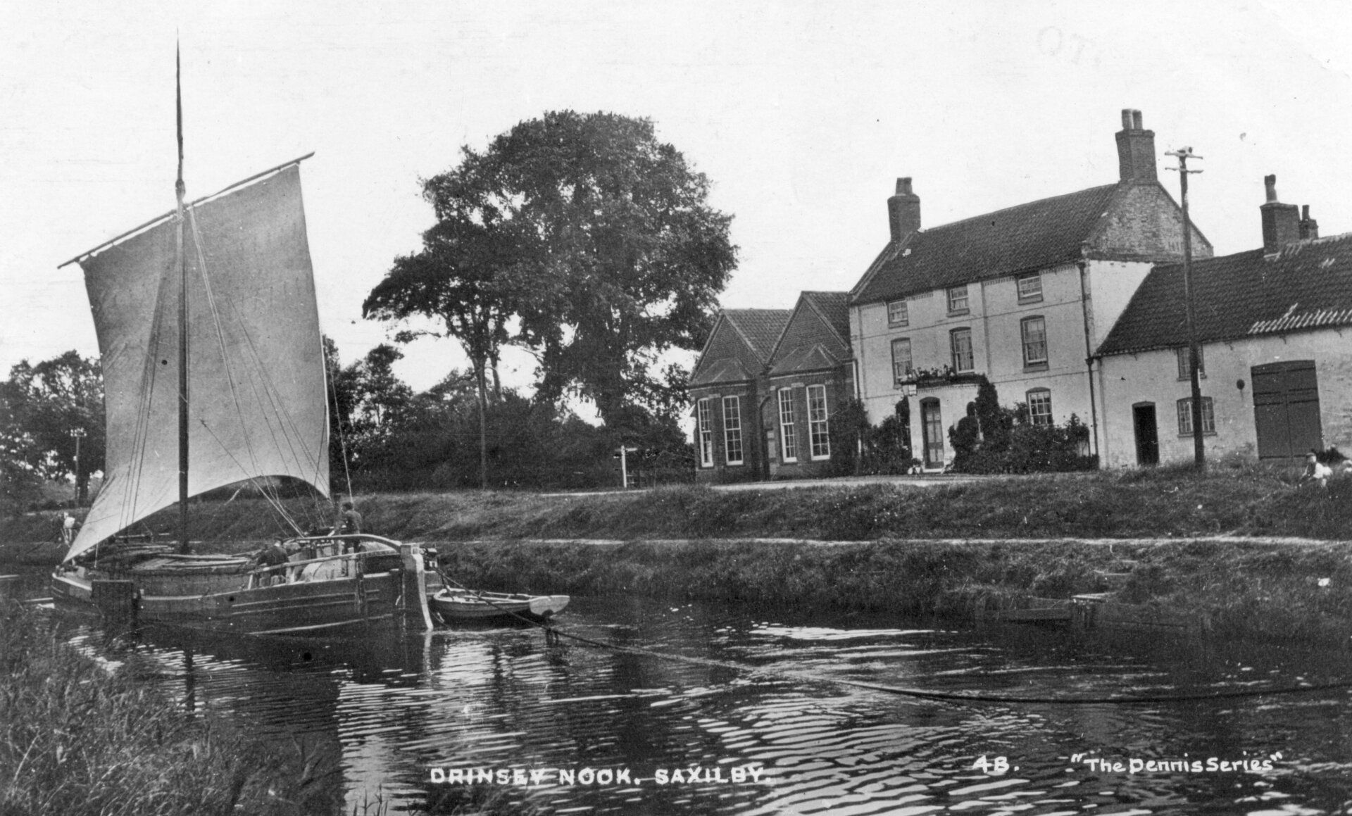

The 'Buffalo' Inn.


The landlord in 1887 was Alfred Tear. He expanded the business, as an article in the 'Lincolnshire Chronicle' of June that year shows – 'Drinsey Nook is surrounded with charming walks, such as would repay anyone at this time of the year, when the trees are in full foliage. Unfortunately however, it has borne in the past a very bad name for the comfort and convenience of visitors, the principal difficulty being in the matter of refreshments of a non-alcoholic nature.

Recently, however, there has been a change in the management, and we are informed that it is now the intention of the proprietors to do all they possibly can towards securing the comfort and convenience of their patrons.

Within easy distance of Lincoln, from which city it can be reached by rail, road and river, there should be no difficulty in rendering it a most popular resort.

Truly a better spot for 'ruralising' could not be had, and with the additional attraction to the lovely walks of fishing and boating in the Foss, which runs by the side of the house, one could very well spend a few days of enjoyment there.

For the convenience of large parties, we are told that there is now a spacious building adjoining the Inn, capable of holding 500 persons, and a capital field near for sports and pastimes.'


The Rev. George Hall, in his book 'The Gypsy's Parson', written in 1914, describes the 'Buffalo' – 'A few miles outside my native city, there stands on the bank of the Roman Fossdyke a lonely house known as “Drinsey Nook”, a tavern with bowling greens, swings and skittle alleys, a resort of wagonette and boating parties out for a frolic in the sunshine. 

Today, as of yore, the brown-sailed barges, laden with grain or scented fir-planks, glide lazily past the place, and a motor-boat will at times go racing by, to the alarm of the waterhens.

One golden October morning, my father hired a small sailing craft, and we were wafted along the Fossdyke as far as the said riparian house of call. Hour after hour we wandered in the beech woods stretching behind the inn. 

Linked with this ramble is an impression I have never forgotten. “Look,” said my father, pointing to a decayed stump of a post, “this is all that remains of Tom Otter's gibbet-tree.'


Hospital


The building to the left of the inn, with the two large windows, was used as an isolation hospital during the Lincoln typhoid outbreak of 1904/5, and as a recuperation hospital for wounded servicemen during WW1.

Prisoner of War Camp


We received a family history enquiry from someone whose Grandfather was a German P.O.W.. Alfred Lessig came to the Camp in 1944. He worked at Orchard Farm, Hardwick. After the war he remained in Saxilby, married a local girl, and died in 1980. He is buried in the churchyard.


This enquiry led us to ask more about the P.O.W. Camp. We are grateful to Ken Kitchen for providing more detail.

There was only one prisoner of war camp in the area at Drinsey Nook. This was a small satellite camp of camp 52, at Nether Headon, Retford. - It opened in 1943 or late 1942 to accommodate Italians who had mainly been captured in north Africa i.e. Benghazi, Tripoli, Tunisia etc.


They were very much ‘Mussolini’ men and when he was deposed and Pietro Badoglio became Italian Prime Minister, they regarded the latter as an arch traitor and were livid.


The Italian POWs worked on local farms mainly. When I became friendly with four or five who worked for Swales initially at Ouseness Farm, they occasionally took me in to the camp to hear them playing a violin. Very musical and Catholic, featuring tunes like Ave Marie which I could then hear.


They went to various places; one was Selby, when finally preparing for repatriation. A Sicilian came back afterwards and brought us a box of Medlars, the first we had seen or tasted. He was then working at Wellingore but I lost touch eventually. Others stayed in touch and we have been to Italy and stayed in one’s home. Sadly all dead, and only the widows remain.


They were industrious hobby-wise in the camp and made all kinds of things with anything they could lay hands on: jewellery from coins and baskets from willows that they collected from the pits by Saxilby railway line. I still have one they made for Mother.


The camp was used for Germans after the Italians vacated, until they too were repatriated. I’m not too sure about later details but the camp probably housed Displaced Persons, because in 1949 I worked at Harby and there were two Ukrainians next door at Pixley’s who were living at Camp 52.

Share by: